3D Model Project
3D Model Project
Introduction:
Crew #6 consist of myself and Connor Klinkhamer and we were tasked with picking a building and creating a quality 3D model with whatever method we wanted. We picked the clubhouse at the Purdue Golf Course as our building and we decided to do a double grid mission overhead, followed by an orbit mission, and finally a walk-around to try and collect the underside of the patio/overhang. The reason we choose this method is because we learned from a previous operation that a double grid NADIR flight is a very successful method to capture the top and surrounding area of the building. We then decided to do an orbit flight around the building because this allows you to capture the side walls and bottom of the building. Finally, we wanted to do a walk around of the clubhouse and manually take pictures at an eye level because there is an overhang that wraps around the building and we wanted to make sure it was included in the 3D model. Due to the location of operation area, we had to get LAANC approval. Our approval code was: ARMP2CW8GOI0
Method:
- Flight 1: Double grid mission, NADIR, 33m
- Flight 2: Orbit mission, 33m, 60 between each photo
- Walk around and manual data collection underneath overhang
Metadata:
Location: Birck Boilermaker Golf Complex
Date:4-27-22
Vehicle: DJI Mavic 2 Pro
Sensor: 1” CMOS
Battery: 1
Approval # (LAANC/COA/Waiver) ARMP2CW8GOI0
Flight Number: 3
Takeoff Time:
First Flight (Double Grid)
Take Off: 9:36am
Landing: 9:46am
Second Flight (Orbit) Take Off: 9:56am Landing: 10:01am
Altitude (m): 33m
Sensor Angle: NADIR
Overlap: 80%
Sidelap: 80%
Cloud Cover: No clouds
Wind Direction: Out of North East
Wind Speed: 7 mph
Temp: 40F
PIC: Connor Klinkhamer
VO: Hunter Donaldson
Results:
Conclusion:
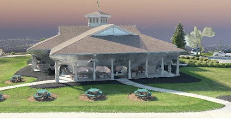
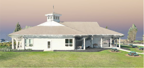
The 3D model turned out pretty well, I am happy with how the building itself looks. The top of the building looks almost perfect, mainly due to the double grid flight that we did. The sides of the clubhouse don’t look as good as the top, but it still looks very presentable. The pillars around the outside turned out better than I thought they would but the orbit mission helped make those visible and precise. The areas under the overhang didn’t turn out as well as we were expecting, but still looks recognizable. The area around the clubhouse was also accurately presented with the sidewalk, bushes, and back tables looking very clear. When looking at the quality report, there are two errors that showed up. The bottom error is just telling us that there weren’t any GCPs detected while processing, but we didn’t use any so that ones okay. The second error tells us that 277 out of 303 photos were calibrated. We discovered that the 26 photos that weren’t calibrated were the ones that were collected during the walk-around. Due to the fact that our orbit mission was flown from a much wider diameter, and the photos from the walk around were collected right next to the building, Pix4D was unable to place those photos in the proper location. That explains why the underside of the patio area didn’t turn out as clean as we wanted it to. If we were to collect the data again, we would want to take the ground level images from the same angle and distance as the orbit flight.


Comments
Post a Comment